Highlights of the Yucatan Peninsula
 The
Yucatan Peninsula lies at the south-eastern corner of Mexico.
The peninsula is larger than Florida and includes the whole of the country
of Belize and
part of Guatemala,
however this page is just about the part of the peninsula which is in Mexico.
The
Yucatan Peninsula lies at the south-eastern corner of Mexico.
The peninsula is larger than Florida and includes the whole of the country
of Belize and
part of Guatemala,
however this page is just about the part of the peninsula which is in Mexico.
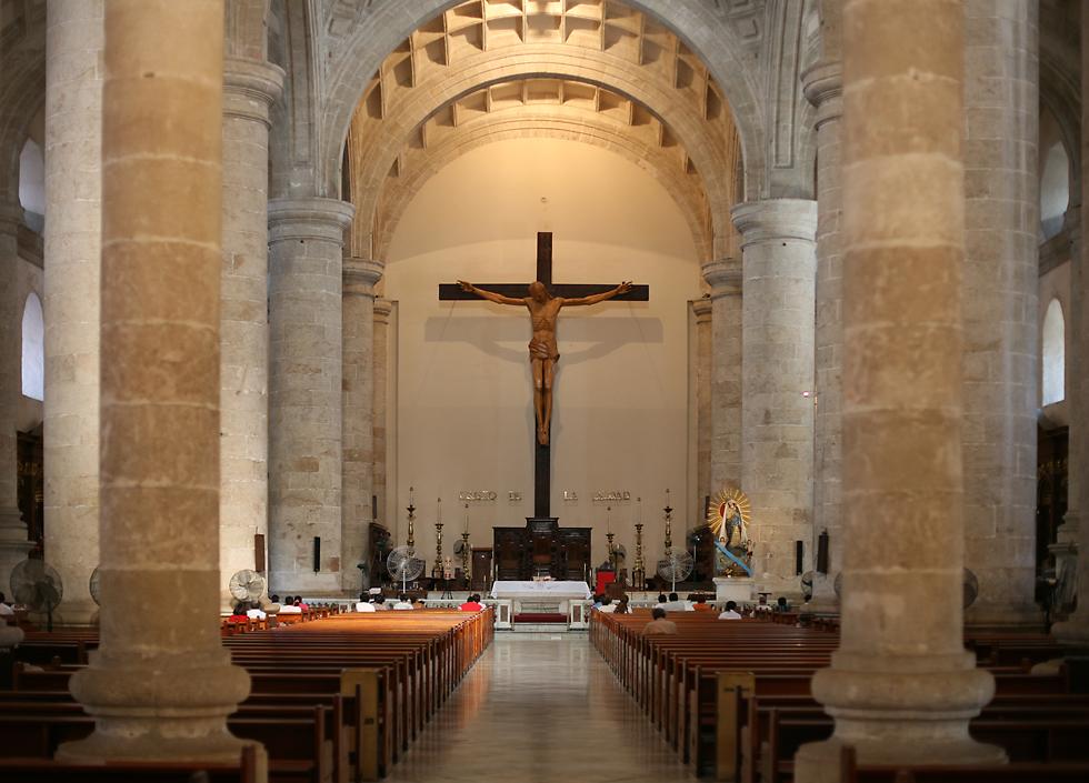
Until fairly recently the Yucatan was always considered somewhat separate from the rest of Mexico, but that isolation definitely ended when the government decided to develop the almost uninhabited north-eastern corner of the peninsula, which they named Cancun. Now almost 200 flights arrive every day, depositing about four million tourists each year. Most visitors spend the time going wild on the beach and perhaps doing day trips to sites around the closer parts of the peninsula. Cancun has a beautiful location, but it's not the sort of thing I'm interested in. Instead, after getting laid off in April of 2009 I took a month-long vacation, including about a week in the Yucatan. I started off with two or three days of scuba diving on the island of Cozumel, then rented a car and did a circuit around the peninsula. I'd heard good things about the city of Merida, which is the capital of the state of Yucatan and by far the largest city. Unfortunately I got lost driving into Merida and its charms were entirely lost on me, since they center on music and dancing, which are of as little interest to me as the beaches and discos of Cancun. I was hoping for some good architecture, but the only slightly interesting building for me was the cathedral, which you see here. |
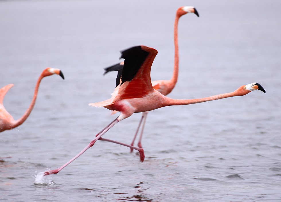
Merida does have attractions for people like me who are interested in architecture and nature, with lots of Maya ruins nearby, and flamingos which live in the nature reserves on the coast near Celestun, about 80 kilometers west of the city. However I didn't go to Celestun! I'd already been to the nature reserve at Rio Lagartos on the northern coast and seen the flamingos there. This turned out to be a good move, the tour there was a lot cheaper than the equivalent tour at Celestun, and when I got to Merida I heard that there were only a handful of flamingos at Celestun at that time. However, I got to see about 80 or 100 all together in a group at Rio Lagartos, as well as many of the other species of waterbirds of the Yucatan. |
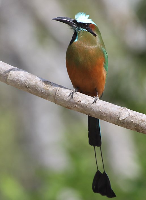
Bird watchers will find that there are plenty of birds inland, too, like this blue-crowned motmot that was at the Dos Ojos cenote. The blue-crowned motmot is fairly common around the Caribbean basin, and even down into South America. It's sometimes called the "clock bird" because of the way it twitches the two "rackets" at the ends of its tail backwards and forwards, like the pendulum of a clock. If you keep your eyes open then you can also see motmots at the Maya archaeological sites, like Chichen Itza and Kabah. |
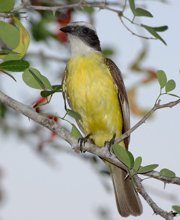
The Great Kiskadee is even more common than the blue-crowned motmot, though not as spectacular. It has an even wider range, all the way from Texas down to Argentina and Uruguay and, unlike the motmot, it can be found in cities. Although they belong to a group of birds called flycatchers, they'll eat almost anything, from insects to rodents, lizards and fruit. They're also very feisty, they'll mob hawks and other raptors to drive them away. The Great Kiskadee's call is said to be similar to the Spanish words "bien te veo", which in English means "I see you well". |

The lineated woodpecker is flashier than the Great Kiskadee. This one was at the very large Maya city of Chichen Itza, and the red mark under its bill identifies it as a male. Like other woodpeckers, this one uses its stiff tail feathers to brace itself against the tree its climbing, hanging on with its large and powerful claws as it pecks away looking for insects under the bark. |
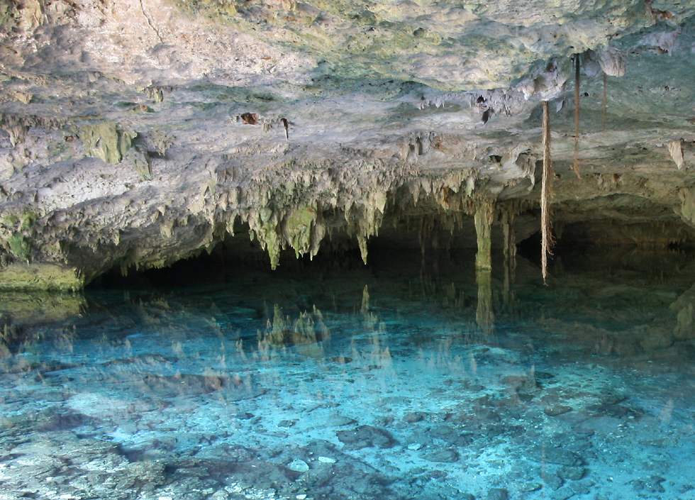
The Yucatan peninsula might be home to a lot of wildlife now, but it's thought that it was ground zero for one of the largest extinction events in the history of the earth. In the 1970s the leader of an aerial oil exploration team doing a magnetic survey of the Gulf of Mexico north of the Yucatan noticed that there was a huge arc about 70 kilometers wide. Looking at an earlier gravity map of the peninsula he found another arc on land, which joined up with what he'd found underwater to form a huge circle about 180 kilometers in diameter. He also noticed something strange about some of the natural limestone waterholes or cenotes which are scattered across the peninsula. In the north-west, many of them were arranged in a long curve because of a corresponding dip in the terrain. Since then, considerably more research has led scientists to believe that a meteorite or asteroid about 10 kilometers across hit the earth a very small distance offshore. The impact had an effect like a stone thrown into a pool, with concentric circles all centered on the same spot, the largest being 300 kilometers across. Dating of this event placed it at the end of the Cretaceous Period 65 million years ago, and today most scientists think it might have been the main cause of the sudden extinction of the dinosaurs at that time. If you travel around the Yucatan, there are certainly plenty of cenotes to see. Many of the Maya cities depended on them for their water supply, because there are no rivers anywhere on the surface of this huge limestone peninsula. This one is called Dos Ojos ("two eyes") because there are two cenotes in close proximity. Limestone is perfect for forming caves, and the two cenotes here are connected by underground tunnels, making it a popular stop for scuba divers, who enter one cenote, swim underground to the other through the crystal-clear water and then return to where they started. |
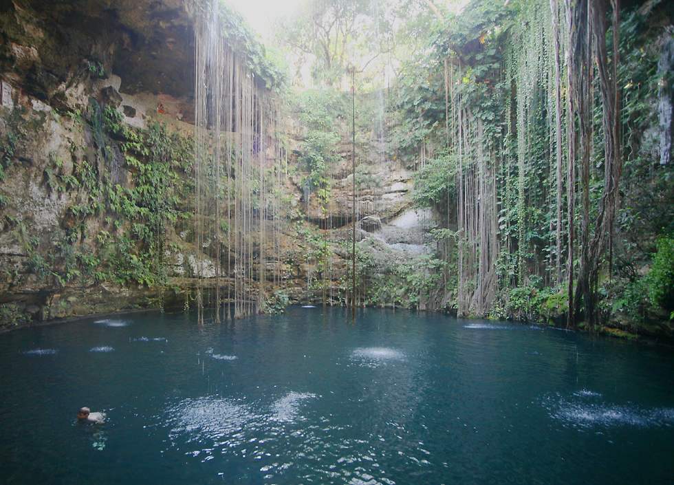
Here's a larger waterhole called The Sacred Blue Cenote, very close to Chichen Itza. It might not be sacred anymore, but it's certainly a popular place for families to go swimming and take a break from the sometimes intolerable heat. |

Another option, of course, is to go to any of the white sand beaches which border the turqoise colored Caribbean Sea along the peninsula's eastern shore. This is the only beach I visited, and only because it's at the Maya site of Tulum, not far south from where I'd been diving off the island of Cozumel. |
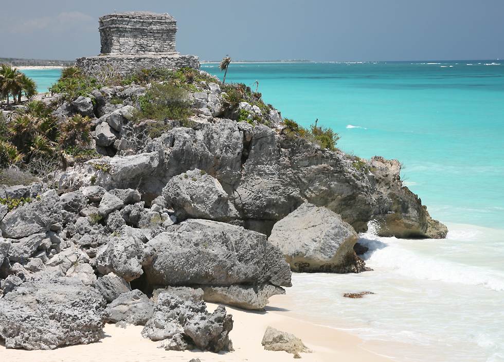
Tulum isn't one of the most impressive of the Maya cities scattered around Mexico's Yucatan peninsula, but because it's close to Cancun and the Riviera Maya, it's one of the most visited. It certainly has the most attractive site of any Maya ruins, perched atop a promontory overlooking the beaches and waters of Mexico's Caribbean coast. It might not be overwhelming for visitors today, but when the first Europeans saw it in 1518 it was still populated and they were impressed by the amount of activity they saw. At that time Tulum's buildings were still painted in blue, red and yellow color schemes, but about 75 years later the Maya abandoned it, as they had already deserted most of the other cities in the area. Tulum's original name was probably "City of the Dawn" because of its eastern location, but the modern name is derived from the Maya word for "wall". The central area is indeed surrounded by a high wall, an unusual feature for Maya cities, and one that probably served a defensive purpose. It's believed that Tulum served as an important center for trade, with items moved by canoe along the coast, and carried by foot deep inland, as far as Tikal in present-day Guatemala. |
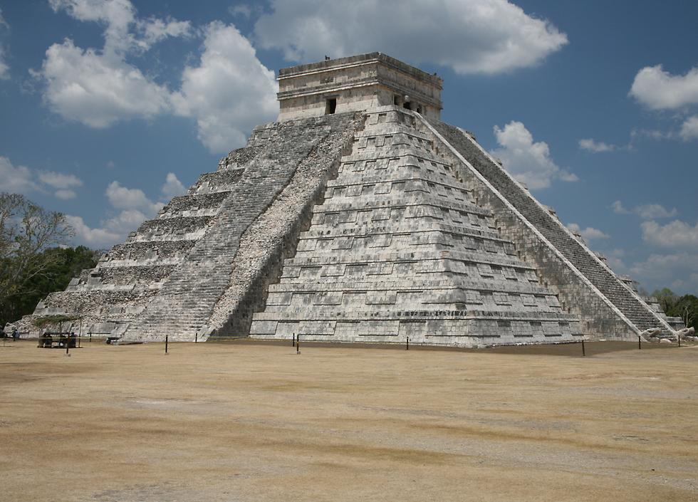
The temple of Kukulcan (often called El Castillo, "the castle" in Spanish) is the signature structure of the ancient Maya city of Chichen Itza, on Mexico's Yucatan peninsula. Many Maya sites, including Chichen Itza and Xunantunich, have a structure with this name, even though none of them served a military purpose. In the same way, names like "The Palace" and "The Nunnery" have been given to many structures at different Maya cities, regardless of their actual function. As with many other Maya temples, it was built on top of an older temple. In the 1930s archaeologists dug a tunnel and found the steps of the earlier building. Following the stairs upwards, they found the room at the top of the buried temple, containing a chac-mool statue of a person reclining on his back and a throne in the shape of a jaguar, painted red with spots made out of jade. The Maya name Kukulcan is the equivalent of the Aztec word Quetzalcoatl, both referring to the "plumed serpent" or "feathered serpent" which is often depicted on buildings in Mesoamerica. Statues of the serpent's head are visible at the base of the stairs on the right-hand side of this photo and, as with other temples in the region, during the Spring and Fall equinoxes the sun strikes the corners of the temple, casting shadows down the outside of the stairs and making it appear as if the feathered serpent himself is descending from the temple. Built around 850 AD, the temple measures 30 meters from its base to the top of the ceremonial building at the summit. As with most Maya temples, there are many astronomical references designed into the structure, for instance, each of the four stairs has 91 steps, which with the platform at the top makes a total of 365, one for each day of the year. Also, each side of the structure has 18 platforms, one for each month in the Maya year. |
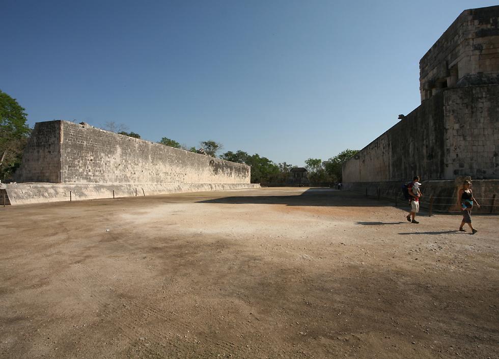
The Great Ball Court at Chichen Itza measures 166 meters long and 68 meters wide, and with walls 12 meters high, it's by far the largest ball court anywhere in Mesoamerica. It's also unusual in having vertical walls, rather than a combination of sloping and vertical surfaces. Carved into the walls are depictions of the members of two ball game teams, one of whose members has been decapitated, with seven streams of blood coming out of the wound. The Mesoamerican ball game was played for over 3000 years from Nicaragua in the south and possibly as far north as Arizona in the USA. Although it had varying rules throughout history and at different locations, the same basic game was played by many cultures, including that of Teotihuacan, the Maya, Olmecs and Aztecs. The game involved hitting a rubber ball weighing up to 9 pounds, either with parts of the body like the hips or sometimes with an implement. The ball had to be kept in play, and in later versions of the game there was a stone hoop (visible in this photo about half-way down the court and about 10 meters up both walls) through which the ball had to pass. The game was also played recreationally and it seems to have been a way of avoiding war between neighboring groups - sometimes one king or ruler would play against another to see who would serve the other. For elite players at a major religious event it was a very brutal and barbaric contest, since at the end of the game the players from one of the teams were killed as human sacrifices. Strangely enough, no-one is quite sure whether it was the losing team which was sacrificed, or the winning team, however it's possible that it was a great honor to be sacrificed, and that being killed would guarantee a better afterlife. Even in non-sacrificial games it was easy to be killed or seriously injured if you were hit hard by the solid rubber ball. |
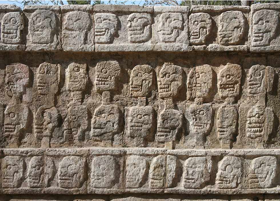
The Tzompantli is a low stone platform near the Great Ball Court at Chichen Itza, whose purpose was to serve as a place to display the skulls of sacrifical victims, perhaps those of the ball players themselves. Carvings of skulls surround the walls around the platform, with stairs leading to the top. The name tzompantli refers to large wooden racks used by different civilizations throughout Central America, with horizontal or vertical poles onto which skulls would be impaled. As you can see from this carving, at Chichen Itza the poles were vertical. At the Aztec Templo Mayor in the middle of Mexico City, there's an even more impressive Wall of Skulls which have been covered in stucco. At this same place a tzompantli was constructed to hold the skulls of Spaniards killed during the initial attempt to conquer the Aztecs, as well as the skulls of their horses, which were a huge novelty in an area where there had previously been no beasts of burden. One Aztec tzompantli was thought to hold up to 60000 skulls, though most were far smaller. |
A jaguar and an eagle carved into the appropriately named Platform of the Jaguars and Eagles, near the Tzompantli at Chichen Itza. This carving is just as gruesome as those on the Tzompantli, since the jaguar and the eagle are both holding a human heart, which presumably has just been taken out of a human sacrifice. It's thought that the bird which is depicted is a harpy eagle, the largest and most powerful raptor in the Americas, quite capable of taking a monkey or sloth from a tree and carrying it away. |
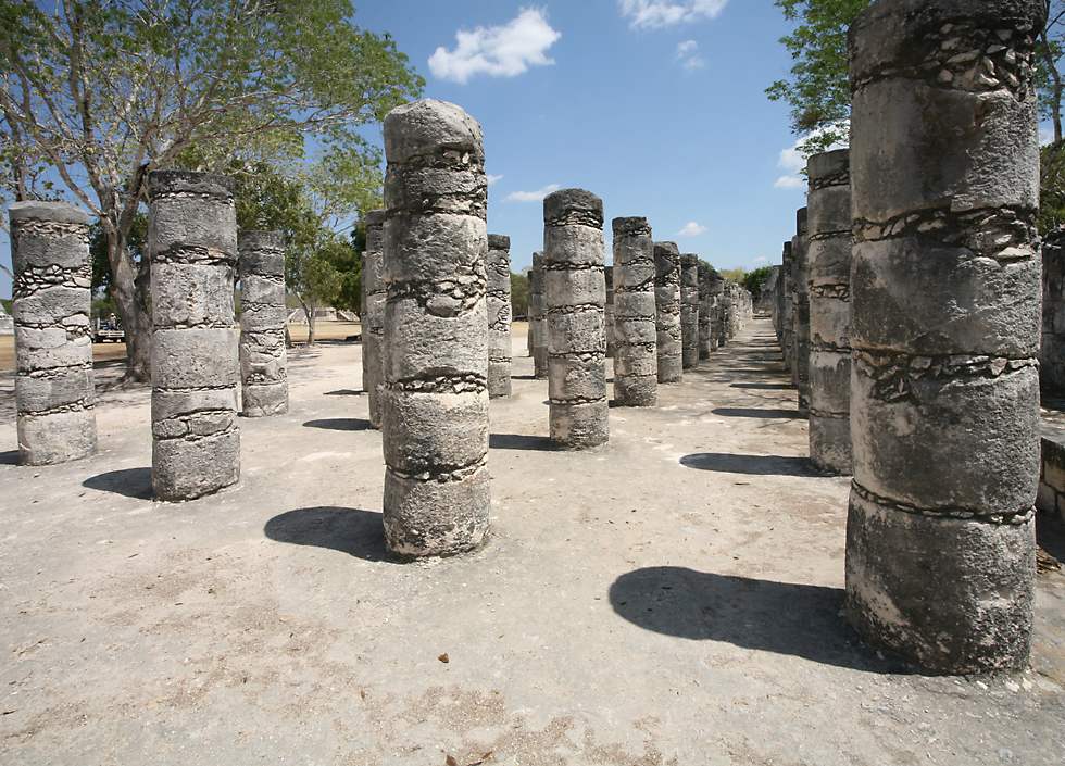
This is part of the Group of a Thousand Columns near the Temple of the Warriors at Chichen Itza. At one time these columns would have supported a roof made of wood and possibly thatch. |
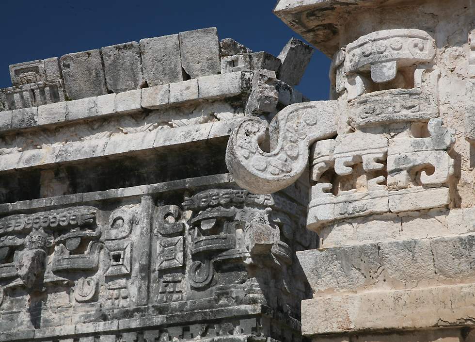
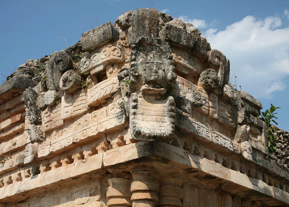
These large masks of the hook-nosed rain god Chac are on the buildings referred to as The Church, at Chichen Itza. The Church is adjacent to a building called The Nunnery but, as with many of the names the Spanish assigned to native buildings, neither really has anything to do with the structures' real purpose. The Nunnery is a large building, about 60 meters long, 30 meters wide and 18 meters high, with many rooms, which might mean that it was a residential building or an administrative center for production of manuscripts. The Maya were the only civilization in Mesoamerica to develop a full system of writing, but over-zealous church authorities gathered up almost all of the manuscripts after the conquest and destroyed them, leaving very few for us to study now. Those that do remain are full of drawings of people and animals, with Maya glyphs, something like Egyptian hieroglyphics, describing the drawings and the rituals which are shown in them. |
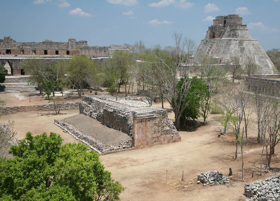
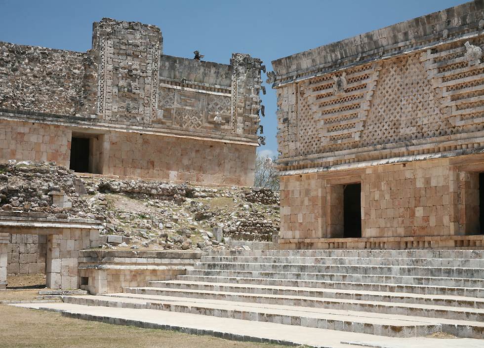
This is part of the Maya city of Uxmal on the Western side of the Yucatan Peninsula along what is now called the "Puuc route" because of the hills in this area ("Puuc" means "hill" in the Maya language). On the right is The Pyramid of the Magician, in the center is one side of a ball court and at the top, left is a corbeled archway leading into a large square called The Nunnery which contains four administrative buildings, one on each side. Uxmal is one of the more impressive Maya sites in the Yucatan, though it's far smaller than Chichen Itza. Many people consider it the most beautiful Maya city because of its many carvings and other decorative features. For most people it's too far from Cancun to do as a day trip on a tour bus, so there are far fewer visitors here than at Chichen Itza - but still a lot more than smaller places like Ek Balam, Mayapan, Kabah and Labna. A road or sacbe linked Uxmal to Kabah, about 18 kilometers away. Uxmal is better preserved than most Maya cities, since it was abandoned fairly late, some time after the 1550s, the buildings were very well constructed using stones laid into concrete rather than mortar, and no Spanish town was built nearby, meaning that the buildings were never pillaged for artifacts or construction materials. |
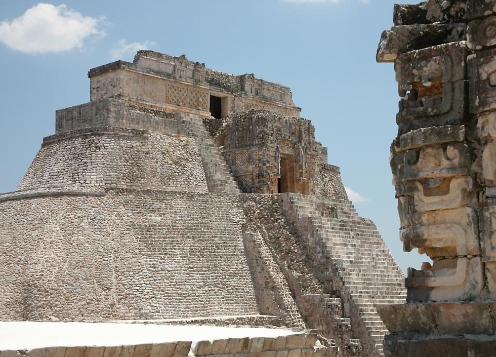
The Pyramid of the Magician at Uxmal has a very unusual architectural style, being roughly oval rather than the usual rectangular form found at most Maya cities. The two sets of buildings at the top are also highly unusual, the lower one being an older temple whose entrance is in the shape of a god or monster, and the higher one being a newer temple. It was very common for the Maya to build one temple on top of another, but at Uxmal the most recent temple was not centered directly on top of the old one, but was constructed slightly to the east, leaving one side of the old temple exposed. In fact, there are a total of five temples from different pyramids built on this one spot. It must have been spectacular in its heyday, because like many Maya structures it was once covered in plaster and painted red, with highlights in blue, yellow and black, but today very few traces of the paint remain. The Pyramid of the Magician is also sometimes known as the Pyramid of the Dwarf, because of a Maya folk tale called The Dwarf of Uxmal. In this tale the governor of Uxmal challenged the dwarf, whose mother was a witch, to a competition of strength and magic, during which the dwarf built the pyramid overnight. You almost have to be a magician to climb it, since it's 38 meters high and has one of the steepest set of stairs in Mesoamerica, which is really saying something, considering how steep the stairs are at Tikal and other places. These ones are bordered on either side by large representations of the face of the god Chac. |
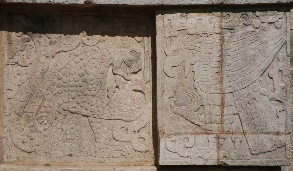
The Quadrangle of the Birds is a small square lined with buildings at the base of the Pyramid of the Magician at Uxmal. It gets its name from the parrot carvings you see here, attached to tile-like blocks carved into shapes like palm leaves, or something similar. As you can see, these are just two decorative elements present in this building, alongside ornamental pillars and a man's head emerging from the mouth of a snake, as at Labna, in both cases a reference to the Quetzalcoatl myth. Ornate decoration is very characteristic of all Maya cities, but those at Uxmal are particularly well preserved and ubiquitous, covering the walls of most buildings. The cities in this region follow what's called the Puuc architectural style, characterised by buildings with plain lower areas but highly decorated upper surfaces, and artificial pillars like the ones in this photo. |
Two of the large buildings in the Nunnery Quadrangle at Uxmal. The four buildings in this large square are built at different levels, which might have a cosmological significance, along with their alignment. Whether that's correct or not, it's certainly true that all four buildings are intricately decorated, with geometric patterns, snakes, masks of the rain god Chac, and many other different figures. |
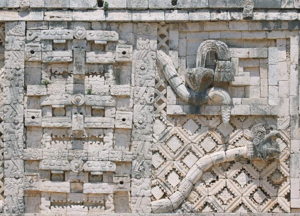
Here's a detail from a 3 meter high frieze on the top half of the western "palace" in the Nunnery Quadrangle at Uxmal. You can see that it's full of geometric patterns, with animals and gods placed either between or on top of those patterns. On the left you can see a spiral figure, which is the Maya representation for clouds and looks similar to the Maya glyph or pictogram for the word "cloud". To the right of the cloud figure are three masks of the all-important rain god Chac placed one above the other. The whole Yucatan peninsula is very arid, but unlike other areas there are very few naturally occuring cenotes in the Puuc region, so cities relied on artificially constructed underground cisterns where rain was collected during the rainy season and stored for use through the rest of the year. This made Uxmal and other Puuc cities like Mayapan, Labna and Kabah even more dependent than other places on placating the capricious whims of Chac. Moving further right there are two more cloud symbols, together with two snakes which stretch most of the 98 meter length of the palace, until they twist together with two other snakes which point in the opposite direction. A human head protrudes from the mouth of the bottom snake in this photo, a symbolic way of asserting the spiritual credentials of the city's ruler, since it is he whose head comes out of the snake, a representation of Kukulcan, the same "feathered serpent" worshipped in other parts of Mexico as Quetzalcoatl. |
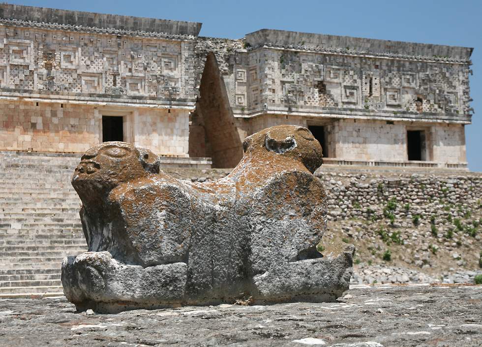
The Palace of the Governor at Uxmal is a very large building in three sections on top of a 10 meter high artificial platform, with a 98 meter long facade said to be the largest on any building in Mesoamerica. It's one of the most spectacular buildings in the Puuc architectural style, covered with over 20000 individual carved stones. The palace is in three sections, with corbeled arches between them, though at some point the arches were filled in to become alcoves. In front of the palace is a low raised platform with four stairs, and on top of the platform is a throne in the shape of a double-ended jaguar. |
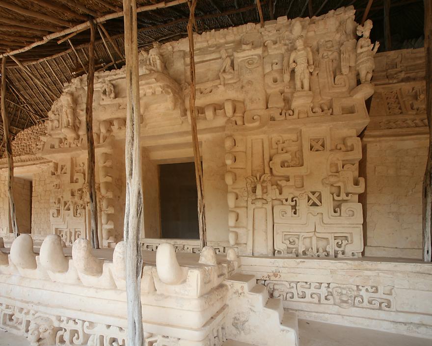
The Maya city of Ek Balam ("black jaguar") is a recently opened site which is between Cancun and Chichen Itza. It's not a large site, but there are some very substantial structures, the largest of which is the 160 meter long and 29 meter high Acropolis. Ek Balam was occupied for a very long time, and pre-dates the much larger city of Chichen Itza, which is about 65 kilometers away. Ek Balam is unusual for having a low stone wall around its perimeter, which might have served just as a demarcation between the inner and outer parts of the city, or might have also had a defensive purpose. There's also a semi-spiral building whose form is unique in the Maya world and whose purpose is unclear, though it might have been related to astronomical observations like the better-known building called El Caracol at Chichen Itza, which is also circular. A final unusual architectural feature is a small building with an arch in each of its four walls, which marked the beginning of several Maya roads or sacbeob. There are other arches marking the start of sacbes at Kabah and Labna, but none with four arches together. These unusual architectural features are of interest to archaeologists, but they wouldn't justify a trip to the site for most visitors. What makes Ek Balam a must see is a set of uniquely interesting statues and other decorative features about two-thirds of the way up the Acropolis, in an area now sheltered by a large thatched roof. This part of the Acropolis was built as a tomb for the city's ruler, Ukil Kan Lek Tok. The entrance to the tomb is made in the shape of a huge jaguar's mouth with large fangs, and around the mouth the walls are covered with decorations in high relief. When he died the ruler was placed in the tomb together with treasures including gold, jade and obsidian, and the whole tomb area was sealed under a thick stone wall. It was only rediscovered by accident when serious restoration work began at Ek Balam in 1997. |
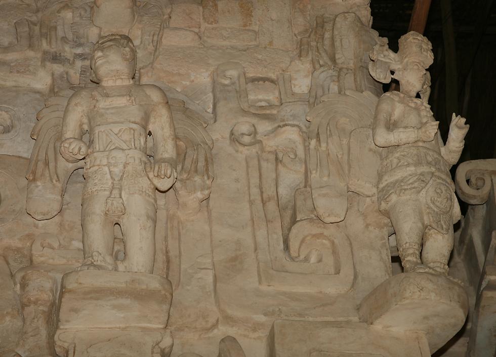
The two most striking decorations around the tomb are these two winged figures, each over a meter high and standing on pedestals which jut out from the wall. It's very tempting to think of them as angels, but they were probably priests in ceremonial dress. Winged figures can be seen at other Maya cities like Mayapan, and even at other distant places in Mesoamerica such as Cacaxtla. The figure on the left is deformed, with a stunted right arm and only four fingers on that hand. Just as the Egyptians often elevated dwarves to positions of high office, so the Maya considered physical differences to be a sign of spiritual powers, so this person might have been made a priest precisely because he had these deformities. |
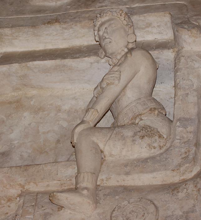
This statue of a woman is also at the tomb of king Ukil Kan Lek Tok in the Acropolis at Ek Balam. She is thought to have been the wife of the king. All of the decoration around this tomb was created from stucco, which is very fragile and usually doesn't survive long, this tomb being an exception only because it was buried soon after it was built. What's even more remarkable about this statue in particular is the very natural portrayal of the woman, her right arm placed very casually across her left and her mouth slightly open as if she didn't know she was being observed. These features contrast very strongly with other cultures' rigid symbolic depictions of people, and imply a very high degree of artistic skill and confidence amongst the Maya artists who created these works. |
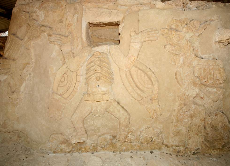
Mayapan is a Maya city founded quite late in the history of the civilization, around 1007 AD, when many cities elsewhere were already collapsing and being abandoned. During its 250 year period of power it exerted control over a large area including major cities like Uxmal and Chichen Itza. There are many architectural similarities between Mayapan and Chichen Itza, but the quality of the buildings at Mayapan is far lower than the earlier buildings at Chichen Itza, a sign of the Maya civilization's impending collapse. At Mayapan there are over 4000 stone structures scattered around a four square kilometer area bordered by a nine kilometer long stone wall, but the most interesting buildings are in the small ceremonial center area. In this area at the base of the main temple, a winged figure stands between two parrots. A niche above the figure would have held a head, either made out of precious materials or a real skull perhaps covered in stucco. |
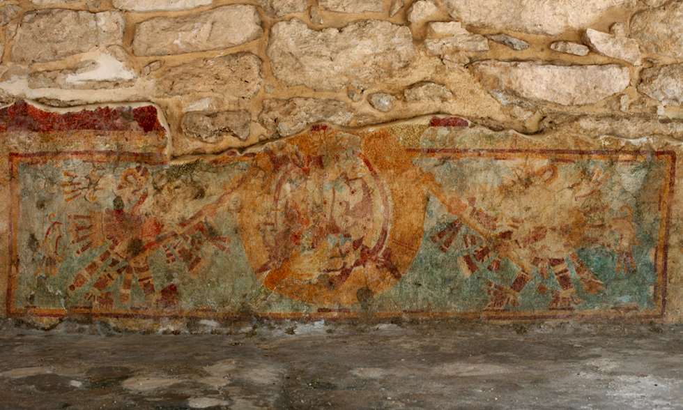
After the military defeat of Mayapan and its destruction by fire in 1441, the last remnants of central government in the Yucatan disintegrated and the individual Maya cities fell into a state of ongoing warfare with each other. When the Spanish arrived the people they met told them that they were men of Mayapan, and this is how the name "Maya" was applied to the entire civilization, both here in Mexico and throughout what are now the countries of Belize, Guatemala, El Salvador, Guatemala and the western part of Honduras. At the base of the temple of Kukulcan at Mayapan is an area with interesting stucco work and murals. Here you see a mural depicting two men with wooden poles holding up a circular banner, possibly a reference to the city's name, which means "Banner of the Maya". |
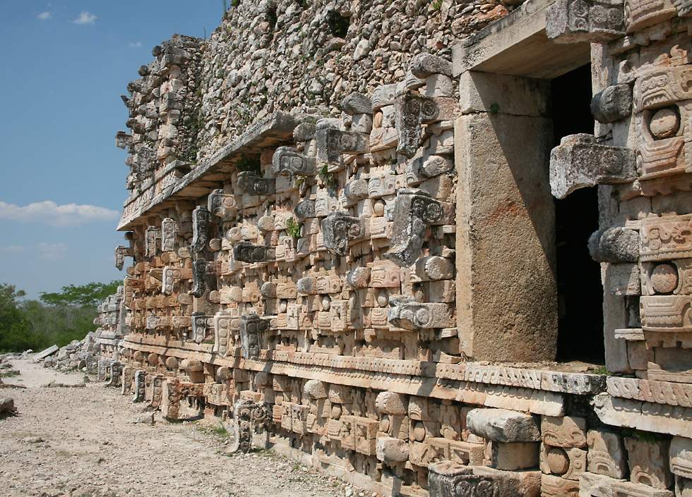
Kabah ("strong hand") is a very old Maya town on the Puuc route. The most famous landmark at Kabah has the English name Palace of the Masks and the Maya name "Codz Poop", which means "rolled mat" in the local dialect. The facade of this temple is covered from one end to the other with about 250 large sculptures of Chac, the god of rain. Each sculpture or mask is made up of individual pieces, eyes, mouth, hooked nose and so on, which were manufactured and then assembled into the final product. This is a particularly arid part of the Yucatan peninsula, without the natural waterholes or cenotes found elsewhere, so the communities established here were entirely dependent on the cisterns they built to capture rain during the wet season. This placed them particularly strongly at the mercy of Chac, so his role was greatly emphasized. |
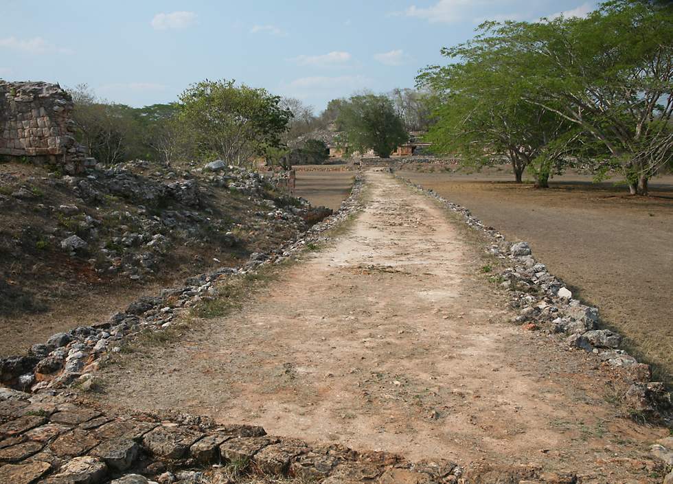
The Maya constructed an elaborate system of elevated roads between major towns and cities using crushed limestone. The limestone is bright white, so they named this type of road a "sac be", meaning "white road", the plural being sacbeob. Since the Maya didn't have horses or other pack animals, and also lacked wheeled vehicles, these roads were only used by pedestrians. The remarkable engineering feats of the Maya are even more amazing considering they didn't have metal tools, but achieved all that they did as a stone-age civilization. |
A decoration on the 120 meter long two-level "palace" at the Maya town of Labna ("city of abandoned houses") which lies on the Puuc route. As with similar carvings at Uxmal and elsewhere, this one shows the head of the town's ruler protruding from the mouth of a snake which is usually identified as Kukulcan, the Maya version of the Aztec god Quetzalcoatl. There are a total of 67 rooms within the palace, some of which are now occupied by tropical birds like swallows and spectacular blue-crowned motmots. As well as the Kukulcan ornamentation, there are the usual Chac masks, false ornamental columns and other standard figures which can be found throughout the region. |
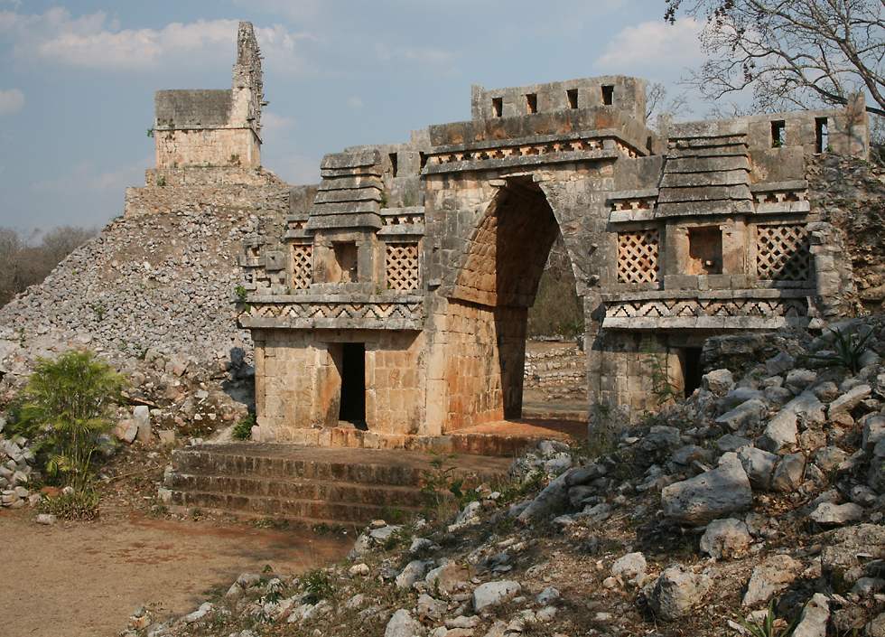
The most spectacular feature at Labna is this six meter high archway, which is by far the most beautiful known arch in the Maya world. It might have been a ceremonial entrance to a sacbe or road, or perhaps it simply provided access between two parts of the town, though it's hard to see why such an elaborate structure would have been built for that purpose. On both sides of the upper section of the arch are two alcoves, within a stylized representation of a Maya hut, complete with thatched roof. These alcoves would once have contained small statues and even today still have traces of the original red and blue paintwork which would probably have covered the entire arch at one time. The other side of the archway is just as well decorated, with spiral and checkerboard patterns which represent clouds and rain. In the background you can see a temple fancifully called El Mirador ("the watchtower"), perched on an artificial hill made of rocks and rubble. It has a four meter high "roof comb" similar to those on temples in the Maya city of Tikal in Guatemala. From the front of the temple and its roof comb, many flat stones project outwards, which would probably once have supported stucco statues like those at Ek Balam. The arch also once had a roof comb, but most of it collapsed long ago. |